Showing posts with label Nature-jungle. Show all posts

Wednesday, June 7, 2017

Lençóis Maranhenses - When to go

Lençóis Maranhenses - When to go


Lençóis Maranhenses - dunes and blue lagoons at the northeast of Brazil

Lençóis Maranhenses - dunes and blue lagoons at the northeast of Brazil


As the Lençóis are very close to the Ecuator line, weather is always hot or warm in this region of Brazil, all year round. It is very windy, so it isn´t an unbearable hot. Sea water is also warm. 

Rains are expected to fall from january to may, so in may the lagoons will reach its maximum water level. Up to the beggining of september, fun is granted, if rains fell substantially during the previous months. 

So, the ends of may untill the beggining of september are the best time to go, since sunny days are expected and the lagoons are suposed to be full. 


Lençóis Maranhenses - dunes and blue lagoons at the northeast of Brazil

Lençóis Maranhenses - dunes and blue lagoons at the northeast of Brazil


November is supposed to be the month when the level of the lagoons is lower, but it depends on rain levels, which can vary. 

However, climate change is obviously modifiyng rainfall in Brazil. Unexpected weather can happen, and nowadays nobody can grant a rainfall period or a dry season in advance. 


Tuesday, June 6, 2017

Atins - another small city close to Lençóis Maranhenses National Park

Atins - another small city close to Lençóis Maranhenses National Park


If you want to stay even more further away from civilization, once visiting the Lençóis Maranhenses, you can try accomodation in the fishermen´s village of Atins, in the mouth of Preguiças river. You can only get there by speed-boats, which departs from Barreirinhas. 


(above, a surfer-dog enjoying its trip alongside the Preguiças river)


These speed-boats can also ride you to the Praia do Caburé, a beach located at a peninsula formed beetween the mouth of Preguiças river in the sea and the ocean, or to the Farol da Preguiça, a lighthouse belonging to Brazillian navy located in the same area. From its top, it is possible to see the river, the sands, the small village and the dunes. 


Brazillian navy lighthouse at Atins, Maranhão


I did a simple day-trip, but resting there for some days wouldn´t have been a bad idea at all.....


Brazillian navy lighthouse at Atins, Maranhão, view from atop


A curitosity in Maranhão state is the declination of the beaches: the slope is very gentle, so you have to go far from the beach to get deep. But speacially in Caburé, the beach is very long and without life-savers, so it is better not to take any risks. 

Brazillian navy lighthouse at Atins, Maranhão, view from atop

Brazillian navy lighthouse at Atins, Maranhão, view from atop

Brazillian navy lighthouse at Atins, Maranhão, view from atop

Brazillian navy lighthouse at Atins, Maranhão, view from atop

Brazillian navy lighthouse at Atins, Maranhão, view from atop

Brazillian navy lighthouse at Atins, Maranhão, view from atop

Sunday, June 4, 2017

LENÇÓIS MARANHENSES


LENÇÓIS MARANHENSES

Getting there


Lençóis Maranhenses - dunes and blue lagoons at the northeast of Brazil


I decided to split the post and repost our tour at Lençóis Maranhenses National Park. Also, I put the marker Lençóis Maranhenses at the scroolbar to the right.

Lençóis Maranhenses - dunes and blue lagoons at the northeast of Brazil

  The closest city to the national park is Barreirinhas, where there are many hotels. It is just a base-village to get to the dunes, so its advisable to take money and all you need, speacially sunblock and mosquito repellent. 


Lençóis Maranhenses - dunes and blue lagoons at the northeast of Brazil

Barreirinhas is 3 and a half hours from the capital of the state of Maranhão, São Luiz do Maranhão (Saint Louis). The SLZ airport is mainly a domestic airport, so to get to Maranhão you´ll probably need a conection in São Paulo, Rio, Brasília or Manaus. There are tour operators which takes tourists from SLZ airport to Barreirinhas, but renting a car can also be a good idea, with a GPS - and caution in the road to Barreirinhas, since it crosses many small villages with many speed-bumps. 

Another option is to come from the state of Ceará and its capital Fortaleza, although it is farther and you would have to cross a small part of the state of Piauí. In this case, trip would be very beautifull and at least two other stops should be added: Jericoacora, the most famous beach in Ceará state, and the "Delta do Parnaíba", the river Parnaíba mouth, in a delta shape. 

Sunday, July 3, 2016

Brasilia´s flowerboom: the ipês season

Brasilia´s flowerboom: the ipês season

Winter in Brasilia - if we can admit there´s any winter in Brasilia - brings the starting of the Ipês´ spectacle.

These big trees start to flourish in the middle of the dry season, and july is the month of the rose ones. 

Some claim the stress caused by the dryness is the responsible for this dramatic reproduction effort of the trees. 

From july to october the big trees of Brasilia bring their different colours alongside the months: in july, the rose ipês; in august, the purple ones; in september, the majestic yellows. In october, the flamboyants wellcome the rain with their heavy canopy fullfiled with red flowers.  

They loose all their leaves, and gain colourful flowers enbelleshing the city. 


There are so many Ipês in Brasilia that we can wonder if the city was made for them, or if the Ipês were made for Brasilia. Surely, the landscaper Burle Marx, who helped Niemayer and Lucio Costa on the task of planning the city, had a great insight when thinking of the Ipês to prettify the city. 

In fact, his gardens are remarkable, though people often look more to Brasilia´s architecture than to its green areas, which deserve the same admiration. The Ipês flowerboom remember us of paying more respect to this perfect combination of nature and landscaping. 

Monday, February 15, 2016

Floripa (3) - The Santinho beach

The Ingleses and the Santinho beaches

The Dunes at Ingleses beach, to the left. To the right, passing over the Dunes,
you can arrive at Santinho beach. But both are accesible by car or bus. 
Still in the north side of Santa Catarina´s island, there are the Ingleses and the Santinho beach.

Ingleses is a very urbanized beach, with a small sandlane. 

Facing the Atlantic Ocean, Santinho is a windy beach, perfect for windsurfing and kite-surfing. Some surfers also enjoy the south side of the beach, close to the rocks. The north side is separated from Ingleses beach by tall dunes, from where nice pics can be taken. 

If you walk from Ingleses to Santinho, this is the scenery you´ll get

The most famous and expensive resort of the island is located at Santinho, the Costão do Santinho resort, built over the stones at the south side.

The dunes hidding the Santinho beach

Alongside the hotel, over the rocks, there´s a path open to the public where some rock art, made thousands of years ago, can be seen in the stones. It is not clear what the paintings in the rocks mean, as they were done by the first humans to settle in the island, much before the Europeans got there. From atop the rocks, nice pics of the beach can be taken.

The path linking Santinho´s beach (in the centre) to Moçambique beach, to the south

The rock art at the rocks of Santinho
For the brave and in good shape tourists, it is possible to continue this path untill the next beach, Moçambique beach. It takes about 2 hours in a 2 km hard trail (1,6 miles). The problem is, if your transportation is at Santinho, you´ll have to come back. Another option is to climb more 1,2 km (about 800mi) uphill to the peak of the mountain. 

More rock art

Friday, February 12, 2016

Florianópolis (1 - the city)

FLORIANÓPOLIS (1 - the city)

Downtown Florianópolis
One of my favorite places in Brazil is undoubtedly Forianópolis, or simply, Floripa.


History and location

The Hercílio Luz Bridge, linking the city of São José, in the continent, with the Island of Santa Catarina, where Florianópolis is. 


The city got the name from Marshall Floriano, a military President of Brazil in the beggining of the XXth century, who massacred a revolt against his government there. As if winning was not enough, he put his name to the city. 

History is history and now kindly known in Brazil by "Floripa", the city is very peaceful and calm, even more considering it is the capital of Santa Catarina state, the second southernmost of Brazil. 

In fact, Joinville and Blumenau are the major cities of Santa Catarina State, a rare situation compared to other Brazillian States, where generally the capital is also the most important and/or populated city.

The two bridges, seen from a boat trip
Floripa is located in one big island, the Island of Santa Catarina, spreading for about 31km north-south, linked to the continent by two bridges, the historic one, called Hercilio Luz, nowadays deactivated but maintained as the city´s postal card and a new one which links the island to the continent by a highway. 

The Hercílio Luz Bridge, linking the city of São José, in the continent, with the Island of Santa Catarina, where Florianópolis is. 

Originally the island was known as Ilha do Desterro (Island of Exile), as it was occupied by the azorians, inhabitants from the Açores archipelago (a portughese possession in the North Atlantic Ocean). 

Even nowadays locals preserve a very strong accent from Portugal, a result of a smallar immigration from other parts of the world. Immigration from Europe, Africa and Middle-East, a common fact in most parts of Brazil, isn´t very much verified here. Santa Catarina´s countryside received lots of germans, italians, poolish and other europeans, but it seems none or few, other than the azorians, have come to Floripa. 

Magic Island
As the Island of Santa Catarina, also known as the "Ilha da Magia" (Magic Island) is big enough for the city, it hosts a strongly urbanized citycentre, in the middle of the island, as well many villages and neighbourhoods spreading alongside its numerous beaches. 

Each beach can host a town or a village, varying from small fishermen´s towns to the high-end Jurerê Internacional beach, separated from each other by mountains, dunes and mangrooves environmentally protected. 

Amongst humble fihsermen and the nouveau riche trying to show-off their wealth, there is place (and beaches) for all tribes, all musics and pockets. So, just choose your beach well - according to your tastes - or just stay downtown to visit the most known of them each day of your stay. 

In the next posts, we´ll travel through the most known and some hidden jewells of Floripa.  


Sunday, September 20, 2015

Salvador (1) - Location

Salvador´s skyline, view from the Bahia de Todos os Santos (All Saints´Bay)

Salvador is in the middle of Bahia State coastline, at the northeast region of Brazil. 


The airport of Salvador (SSA) is one of the most busy in Brazil, and receives lots of international flights too, from Europe, the US and South America. 

Salvador da Bahia airport - SSA

Salvador da Bahia airport - SSA

But one must pay attention: don´t mix Salvador da Bahia with San Salvador, the capital of El Salvador, in Central America. Be mindful of IATA´s code SSA before buying your airticket! It became famous in Brazil the history of an australian couple who was mistakenly sent by their tour operator to El Salvador instead of Salvador da Bahia during 2014 World Cup. 

As Salvador is located in one of the entrances of the Bahia de Todos os Santos (All Saint´s Bay), reaching Bahia´s south coast is harder by car, because cars must turn all the bay around, which is quite big; this turn-around can take very long time. 

Another option for cars is to take the ferry boat from another point of Salvador´s harbor to Itaparica, the island at the opposite entrance of the Bay. This ferry can also be taken by pedestrians, but you´ll need a car or a shuttle at Itaparica. 

The problem is that this ferry gets very, very crowded during carnival, end of the year and other brazillian holidays, making this option unadvisable at these times of the year. 


Aerial view of Salvador


Bahia´s south coast can be easily reached, as an option, through Ilhéus airport, a city 311km to the south. But Ilhéus is a smaller, domestic airport, so to foreigners it can be a bit difficult to get there unless you´re coming from another Brazillian capital. 

Saturday, September 19, 2015

Bahia, land of wonderful beaches, sun and brazillian-afro culture


Bahia, land of wonderful beaches, sun and brazillian-afro culture


Bahia State and its capital city, Salvador, fascinates many tourists for its afro-brazillian culture, its strong and spicy food, marvellous beaches, all-year-round heat and sun, and its historic buildings.


The acarajé, a kind of fried and spicy pastel, is the most famous dish of Bahian culinary, but Brazillian classics as the feijoada and the caipirinha can be allways found in Bahia. Seafood is in every coast city. 


Though Bahia is most famous for Salvador´s carnival and historic sites, as well for the incredible beaches alognside Bahia´s coastline, the State countryside hosts the Chapada Diamantina, a rocky formation with rivers, caves, cosy villages and lots of nature in the region of Lençóis, a countryside city located 426 km (about 300 miles) west from Salvador. 


In the days to come, we´ll see some parts of this magic Brazillian State. 


Monday, September 14, 2015

Chapada dos Veadeiros 9 - Abyss and Window waterfalls

Chapada dos Veadeiros 9
 Abyss Waterfall and the window stone


(Cachoeiras do Abismo e da Janela)

This is the harder track of all I´ve done in the Chapada dos Veadeiros. It starts in a vistapoint over a hill, about 2 km away from the village of São Jorge. Atop this hill people leave their cars to start the trail, and it is common to see people camping there. 


This track demands really good physicall preparation. First, trackers must get down this hill towards an environmentally protected area, though private. There´s a guy charging a small fee for entering the area. The track goes by dense jungle and also cerrado fields, taking about half an hour to arrive atop the Abyss Cascade (Cachoeira do Abismo). 


The name is exactly what it means: an abyss among the rocks, from where trackers must get down to a valley, to later climb up again another mountain. The abyss cascade only exists during the rainy season, as it is part of an intermittent river. 

But stoping there to take a bath and grab some water is precious, specially when you come almost dead in the back journey. Many tourists don´t go on, and stay at the Abyss Cascade waiting their most courageous friends who decided do to go on. Enjoying this view isn´t bad:

The view from the Cachoeira do Abismo - Abyss Waterfall in Chapada dos Veadeiros National Park

If you are among the courageous, know that you didn´t reach half way. Getting down to the valley is easy, though one must be cautions, since the mountain is very sharp. At some places there are stairs and wooden handrail to help. 

Once in the valley, a short walk leads to the rocks and stairs leading atop the next mountain, and this is very hard climb, because this mountain is also very sharp. 

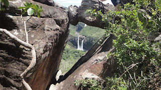
Once atop, the view is superb. It seems all the Chapada is under your feet, and you can see the huge Jump Waterfall quite small many meters under you.


But if you have a good guide, he can take you to the window stone, to see the Salto do Rio Preto Waterfall, which is nothing more, nothing less than the very "Jump of Rio Preto river" Waterfall inside the National Park. 


Enjoy this incredible view while you take a breath to do all the way back!


SP GLBT Pride - the best places to dance

São Paulo´s LGBT Pride - the best parties and discos to dance Avenida Paulista, where every year, at june, the São Paulo gay pride i...